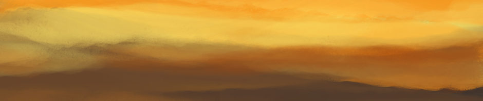
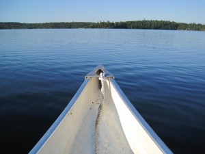
Staring blankly out the window at the passing scenery (sic), I begin to wonder whether a catatonic state can be induced by endless repetition. Trees. Rocks. Water. Repeat.
Happily, my unease about my mental health is muted by my general numbness. Welcome to the Canadian Shield.
Welcome Tourist To The Canadian Shield:
Throughout this brochure you will be fascinated
by the wonders of the Canadian Shield.
– Source: Calgary Board of Education
(Student work? I’m guessing so.)
If fascination is on this menu, the brochure must be significantly tastier than its topic. Sorry, did that sound harsh? I apologize. I’ll try to keep it to just the facts, ma’am. Maybe with the merest soupçon of commentary.
The Canadian Shield refers to the exposed portion
of the continental crust underlying North America.
– Source: Canadian Encyclopedia
If you’re thinking that “continental crust” sounds a lot like “rocks,” you’d be right. A lot of rocks.
In the Canadian Shield there are lots of trees and rocks.
– Source: Calgary Board of Education
This statement may be a candidate for Understatement of the Millennium. For as far as I can see out the car window, in all directions, there are trees and rocks, trees and rocks. And those trees and rocks go much further than I can see.
It covers most of the NWT
(Ed.’s note: And Nunavut, these days.),
a corner of Alberta, half of Saskatchewan, half of Manitoba,
and all of Ontario and Quebec.
– Source: Galileo (More student work, apparently.)
Experts agree that the Shield covers more than half of Canada. Or almost half. Whatever. Maybe a visual will help. Maybe not.
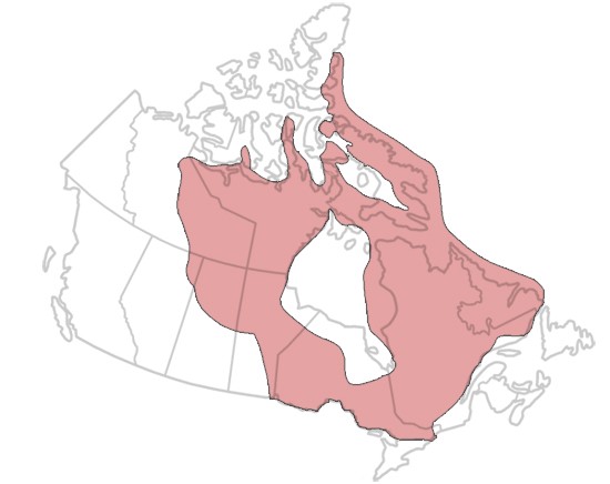
Almost half? More than half? You be the judge.
Having strained themselves to reach this level of approximate accord, the experts diverge on the exact area: Is it the 5 million km2 (reported by the Nature Conservancy of Canada) or the 8 million km2 (cited by two encyclopedias: Canadian and Britannica)?
Whatever. Quibbling over these admittedly divergent size estimates would miss the point. Like the guy who didn’t have 20 years of experience so much as he had 1 year of experience 20 times, the Canadian Shield isn’t 5 or 8 million km2 so much as it is 1 km2, 5 or 8 million times.
No, that’s too harsh: I apologize again. To be fair, based on my rigorous observations from Yellowknife to Goose Bay, the Canadian Shield is actually four packets, each 1 km2, repeated as necessary to get to whatever the total area is.
Packet #1 – The Square Kilometre of Mostly Trees
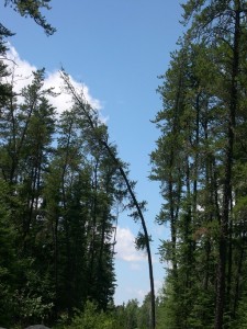
Mostly trees
As a matter of fact there isn’t a lot of depth to the soil
(Ed.’s note: Ya think?).
Trees like the fir, pine and spruce love it here
but the shallowness of the soil
wouldn’t work for plants that have a deep root system.
– Source: Ednet (Student work again? What’s with this?)
Packet #2 – The Square Kilometre of Mostly Rocks
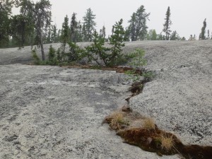
Mostly rock. And smoke.
It is the Earth’s greatest area of exposed Archean rock.
(Ed.’s note: All those who know what Archean rock is,
raise your hands.)
– Source: Canadian Encyclopedia
Packet #3 – The Square Kilometre of Mostly Water
Mostly water
Most of the water in this region
drains into the Hudson Bay, James Bay,
and the Atlantic Ocean. (Ed.’s note: But first into one of hundreds of thousands of lakes. Hundreds. Of. Thousands.)
– Source: Calgary Board of Education
Packet #4 – The Square Kilometre of Boggy Swamp
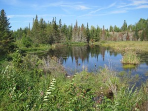
Trees, rocks, and water: a boggy swamp
Some of the water drains into the many swamps and bogs
scattered in this region. (Ed.’s note: I hereby attest
to the many-ness of these swamps and bogs.)
– Source: Calgary Board of Education
Synergy and Its Antithesis
Synergy is the whole being more than the sum of its parts. The Canadian Shield is the quintessential antithesis of synergy.
Trees, rocks, and water: all good things, whether singly or in combination. But after three days of mind-numbing travel across one tiny corner of the Canadian Shield, I have the capacity for only two thoughts, and they are these.
You can have too much of even a good thing.
We still have to drive home.

Having at one time owned a cottage perched by a lake on said Canadian Shield I can say that taking possession of a small part of it and getting to know it produces an enchanting and richly rewarding set of experiences. Trees + water (including swamp) + rocks = sheer delight. Just how little soil supports those towering pines was revealed when a tornado swept across the north end of the lake. Dozens of fallen trees revealed their pancake base of sand and an almost circular root system that flipped off the rocks as neatly as flapjacks off a seasoned frying pan.
Laurna – It is amazing to me how little soil there actually is. The trees truly seem to cling to, and grow out of, bare rock.
Reading “Trees. Rocks. Water. Repeat.”, I was reminded of a raft trip many years ago down the Colorado River through the Grand Canyon – not the paddling kind, but the one where you relax and look at the scenery while someone pilots the (sometimes) motored pontoon raft around and/or through the rough bits (rapids ranging from mild to violently disconcerting).
At the beginning of the week-long trip, everyone had the camera out when allowed (not in the rapids), taking hundreds of photos on slide/print film. Somewhere on the sixth or seventh day, when someone noted that no one was taking photos any more, another, still gazing at the rocks passing by, offered, “Rocks and water, just more rocks and water.”
Marion – We had a similar reaction at Western Brook Pond in Newfoundland. It’s a “captured fiord,” with no outlet to the sea. Amazing cliffs. But after a while, especially on a grey day with a low ceiling, it was just grey rock, grey sky, grey water – with some grey-green trees for variety! I suspect that even on a bright day all the photos would look the same. I suspect that a different vantage point would help – like the helicopter view of this selfsame area on the official provincial tourist agency ads. Or, of course, I could put the camera down and just be in the moment . . .
Yes, that sort of visual “stimulus” can produce a dangerous catatonic state. Don’t drive under its influence… self-driving cars can’t come soon enough.
So does farm machinery and bored, mesmerized farmers looking at it — they’ll put their hands in those harmful moving parts just to see what will happen.
Secondly, those hundreds of thousands of lakes/ponds are what give us all the summer clouds we see, those little puff clouds, so prettily spaced. Each one is the evaporation of a little body of water — judge the size by the cloud size.
And thirdly, I went to three Institutions of Higher Learning, getting enough course credits worth a degree — but the final requirement required by my last school attended — the U. of California @ Santa Barbara — was geology. I just refused. I was right to do so. Viz., Archean rock — why know the name for something nobody ever talks about?
Got married instead. My parents never complained: it was why I was sent to college in the first place. Those were the days. Does that still happen?
Barbara – Yes, it’s almost as bad as driving into driving snow – not quite as hypnotic, but much more stupid-making. The Canadian Shield should come with a warning label: Consume only in small quantities. As for going to school to snag a spouse – I don’t know whether that still happens!