
Finishing up a rainy but great week on the Left Coast, I start looking ahead to some social arrangements with friends upon my return to, and before my next departure from, Ottawa.
Given an unfamiliar suggested rendezvous, I naturally ask Google Maps to find it and to give me a sense of how long it will take to get there from my home.
At least, that’s what I mean to ask. Instead, I ask for directions from My Location: Comox BC. Oops. And OMG. Google Maps gets as excited as I’ve ever seen it.
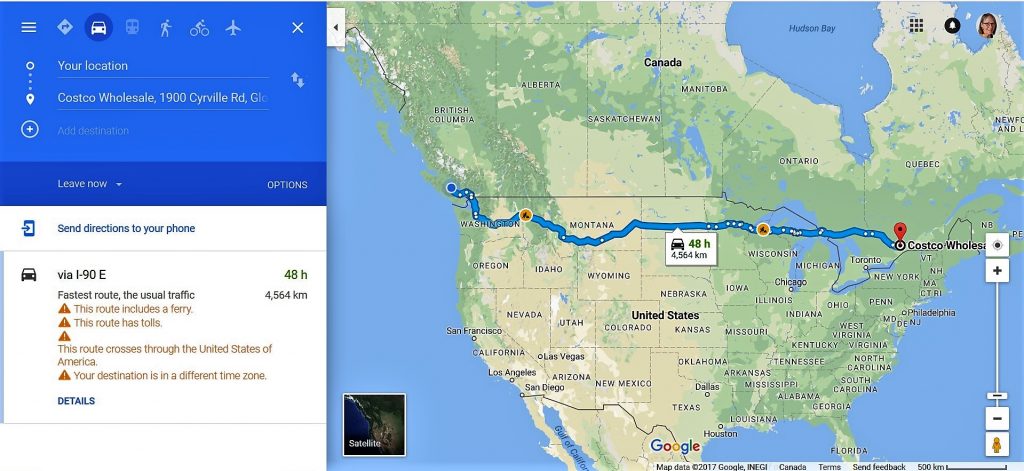
Using any old east-end Ottawa location to illustrate.
Watch out! This route includes a ferry.
Yes, that would be to get off Vancouver Island. It’s OK.
Alert! This route has tolls.
OK, I might reasonably expect to hit toll roads or bridges somewhere in the 4,564 km. What’s next?
Argghh!! This route crosses through the Excited States of America.
Thanks, I can see that, although most of the states actually crossed are calm, bordering on boring, frankly. Anything else?
Oh no! Your destination is in a different time zone.
A different time zone? That tears it. I’m not going. I’m so glad I checked.

I tried several times lately to get my trusty Garmin GPS to take me to a small village…well, actually, barely a crossroads with a name…and the GPS just gave me a blank stare. A long road to nowhere I guess.
Tom
Tom – You can use the map function to choose a location (dropping a pin, I think) and I’ve done that successfully a few times. Of course if you know the lat/long coordinates, you could use those too. 🙂
Hilarious — unintended? or are the robots who set this up evolving?
Barbara – I don’t know which I’d prefer to be true: that they’re evolving a sense of humour, or that there is at least some small corner of the world that we can still safely take at face value.
I love playing with Google Maps, horizontal, vertical, satellite, 3D, you name it. It’s a great tool. To poorly paraphrase Tennessee Williams, however, I have always depended on the presence of roadmaps, despite the inconveniences of holding these awkward-folding, easy-tearing, too big, hard to read, hold, scan and drive at the same time with your reading glasses pointed to your lap and your long-distance eyes scanning the horizon direction-finders. When I am on the road, I want my roadmaps. I can’t follow computer displays that are too hard to follow, especially that guy Sean with the Irish accent, however rib-tickling his pronunciations may be. I want the reliable, hopefully recent Rand McNally in my hand, torn, coffee-splashed, sticky from donut sugar or ketchup. My father swears that gas stations across the major highways started charging for road maps after my siblings and I would tear out of the station wagon at pit stops–this was long ago and we would be on some two-week expedition to one relative or another–and relieve the attendant of all their maps while they were filling up the vehicle. When I look at a road map, I am looking at the terrain, the surrounding communities, the distances between them, the secondary roads, and so forth. My son depends on Google Maps. When we travel, I want my map in hand, while I ask him where the next turn is.
Marilyn – Your dad is funny, but maybe there is a causal correlation there. We could Google that, I guess. I know what you mean about having the larger picture: orientation helps, especially outside urban centres. On the other hand, in a big city or mess of interlocking freeways, I love having the step-by-step directions.